SAFETY – SAFETY – SAFETY | THERE IS NO SUBSTITUTE
THE BASIC RULES OF DRONING 2021
Fly at or below 400 feet
Keep your drone within sight
Don’t fly in restricted airspace
Don’t fly near other aircraft, especially near airports
Don’t fly over groups of people

- Don’t fly over stadiums or sports events
- Don’t fly near emergency response efforts such as fires
- Don’t fly under the influence
What is a Recreational Flight?
Many people assume that a recreational flight is one that is not operated for a business or any form of compensation. But, that’s not always the case. Financial compensation, or the lack of it, is not what determines if the flight is recreational or commercial. The following information can be used to help you determine what rules you should be operating under. Remember, the default regulation for drones weighing under 55 pounds is Part 107. The exception for recreational flyers only applies to flights that are purely for fun or personal enjoyment. When in doubt, fly under Part 107.
- Note: Non-recreational purposes include things like taking photos to help sell a property or service, roof inspections, or taking pictures of a high school football game for the school’s website. Goodwill or other non-monetary value can also be considered indirect compensation. This would include things like volunteering to use your drone to survey coastlines on behalf of a non-profit organization. Recreational flight is simply flying for fun or personal enjoyment.
What are the Rules for Recreational Flyers?
The Exception for Limited Operation of Unmanned Aircraft (USC 44809) is the law that describes how, when, and where you can fly drones for recreational purposes. Following these rules will keep people, your drone and our airspace safe:
- Fly only for recreational purposes (enjoyment).
- Follow the safety guidelines of an FAA-recognized Community Based Organization (CBO).Note: We have not yet begun officially recognizing CBOs. Recreational flyers are directed to follow the safety guidelines of existing aeromodeling organizations or use the FAA provided safety guidelines per Advisory Circular 91-57B.
- Keep your drone within the visual line of sight or use a visual observer who is co-located (physically next to) and in direct communication with you.
- Give way to and do not interfere with manned aircraft.
- Fly at or below 400′ in controlled airspace (Class B, C, D, and E) only with prior authorization by using LAANC or DroneZone.
- Fly at or below 400 feet in Class G (uncontrolled) airspace.Note: Flying drones in certain airspace is not allowed. Classes of airspace and flying restrictions can be found on our B4UFLY app or the UAS Facility Maps webpage.
- Take The Recreational UAS Safety Test (TRUST) and carry proof of test passage (coming soon).
- Have a current registration, mark (PDF) your drones on the outside with the registration number, and carry proof of registration with you.
- Do not operate your drone in a dangerous manner. For example:
- Do not interfere with emergency response or law enforcement activities.
- Do not fly under the influence of drugs or alcohol.
Individuals violating any of these rules, and/or operating in a dangerous manner, may be subject to FAA enforcement action.
READ MORE —>
PITCH ROLL YAW – YOU MUST UNDERSTAND THESE MOVEMENTS TO BEGIN.
READ MORE —>
PITCH ROLL YAW – YOU MUST UNDERSTAND THESE MOVEMENTS TO BEGIN.
https://www.dronepilotgroundschool.com/missed-part-107-test-prep-questions/
Above Ground Level, or AGL, describes the literal height above the ground over which you’re flying. Mean Sea Level, or MSL, is your true altitude or elevation. … Pilots use altimeters, which measure the AGL, when the aircraft is flying at relatively low heights landing at an airport.
HOW TO READ AN AERONAUTICAL CHART
https://www.youtube.com/watch?v=6ITjUfl80bs
– WHAT DO YELLOW AREA’S MEAN?
– MAGENTA = NON TOWERED AIRPORT
– BLUE = IT IS A TOWERED AIRPORT – SURROUNDED BY CLASS D RING
– WHAT IS CLASS G AIRSPACE? FROM GROUND TO WHAT?
– CLASS D UP TO 2,500
https://www.nationalgeographic.com/science/article/how-to-read-an-aeronautical-chart
5 MILES = 26,400FT | MAVIC AIR II RADIUS
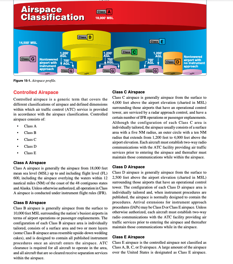
*** Class G airspace is typically the airspace very near the ground (1,200 feet or less), beneath class E airspace and between class B-D cylinders around towered airstrips. Radio communication is not required in class G airspace, even for IFR operations.
Class G is completely uncontrolled.

